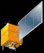
CBERS-2 SATELLITE SENSOR

The CBERS-2 identical to CBERS-1 Program was born from a partnership between Brazil and China in the space technical scientific segment. CBERS-1 was launched successfully on October 21, 2003 from the Taiyuan Satellite Launch Center in China. The launch time was 11:16AM (Beijing local time), which corresponds to 1:16AM (Brasilia local time). Satellite images from CBERS-2 are used in important areas, as deforestation and fire control in the Amazon Region, water resources monitoring, urban growth, soil occupation, education and several other applications. One important application is the hydrological basin monitoring by the ANA and SIVAM platform networks, which provides Brazilian river and rain data.
CBERS Satellite Sensor
Image Credit: China Brazil Earth Resources Satellite/INPE
The CBERS satellite is composed of two modules. The payload module houses the optical system (CCD - High Resolution CCD Cameras, IRMSS - Infra-Red Multispectral Scanner e WFI - Wide Field Imager) and the electronic system used for Earth observation and data collecting with a resolution capability ranging from 20 meters to 260 meters. The service module incorporates the equipment that ensures the power supply, control, telecommunications and all other functions needed for the satellite operation.
CBERS-2 SATELLITE SENSOR SPECIFICATIONS
Resolution 20m - 260m
Launch Date October 21, 2001
Launch Location Taiyuan Satellite Launch Center in China
Total Mass 1450kg
Power Generation 1100w
Sun-Synchronous Orbit 778km
14 revolutions per day
Equator Crossing Time 10:30 am
Lifetime Orbit 2 years
CBERS-2 OPTICAL SPECIFICATIONS
The CBERS-2 satellite sensor was designed for global and scalable coverage that include cameras that make optical observations and to collect data on the environment.
The unique characteristics of CBERS-2 are its multi-sensor payloads with different spatial and spectral resolution capabilities and frequencies from each camera allowing for various mapping applications.
WFI - Wide Field Imager — Large Territories (890km wide) — 5 day interval
Spectral bands 0,63 - 0,69 Μm (red) 0,77 - 0,89 Μm (infrared)
Field of view 60 °
Spatial resolution 260 x 260 m
Swath width 890 km
Temporal resolution 5 days
RF carrier frequency 8203,35 MHz
Image data bit rate 1,1 Mbit/s EIRP 31,8 dBm
WFI - Wide Field Imager Camera
Satellite Image - South America
Image Credit: China Brazil Earth Resources Satellite/INPE
Large scale mosaics
Vegetation indexes and land cover change detection for monitoring purposes
Monitoring of agricultural harvests, canopy assessment, tree grading, deforestation, forestry, wildfires/forest fires, and infestation
Joint operation with other world data
CCD - High Resolution Camera — Detailed City and Region Studies
Spectral bands 5
0,51 - 0,73 Μm (pan)
0,45 - 0,52 Μm (blue)
0,52 - 0,59 Μm (green)
0,63 - 0,69 Μm (red)
0,77 - 0,89 Μm (near infrared)
Field of view 8,3°
Spatial resolution 20 x 20 m
Swath width 113 km
Mirror pointing capability ±32°
Temporal resolution 26 days nadir view (3 days revisit)
RF carrier frequency 8103 MHz e 8321 MHz
Image data bit rate 2 x 53 Mbit/s EIRP 43 dBm
CCD - High Resolution Camera
Satellite Image - Beijing
Image Credit: China Brazil Earth Resources Satellite/INPE
CCD Camera supports the analysis of phenomena whose duration is compatible with its temporal resolution. This temporal resolution can be improved as the CCD has the capacity of side view. Its bands are located in the spectral zone of the visible and near infrared, which allow good contrast between vegetation and other type of objects:
Vegetation
Agriculture
Environment
Water
Cartography
Geology and soil
IRMSS - Infrared Multispectral Scanner — Spectral coverage (120km wide) — 26 days
Spectral bands 4
0,50 - 0,80 Μm (panchromatic)
Field of view 2,1 °
Spatial resolution 2,7 x 2,7 m
Imaged strip width 27 km (nadir)
Temporal resolution 130 days in the proposed operation
Quantization 8 bits
IRMSS - Infrared Multispectral Scanner
Satellite Image - Dam on Piranhas (or Açu) River, Brazil
Image Credit: China Brazil Earth Resources Satellite/INPE
Analysis of surface temperature modifications
Large scale mosaics
CBERS-2 SATELLITE IMAGE GALLERY
Please visit our CBERS-2 Satellite Image Gallery for sample images.
For more information on our products or services, please contact us.
--
