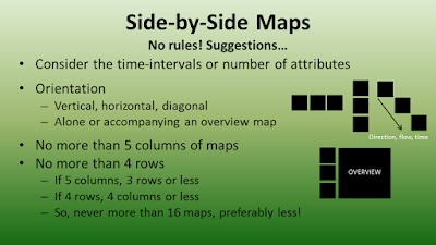
QGIS has a powerful print composer that allows users to create complex maps very quickly. Two common practical examples include creating: 1) side-by-side (or multiple maps) on the same canvas/layout and 2) a map book or atlas. This week's video looks at these cases:
.
In the video, we will create side-by-side maps of different band combinations of remote sensing imagery of the Salton Sea. For a related blog post, visit:
http://opensourcegisblog.blogspot.com/2015/08/tutorial-side-by-side-maps-in-qgis.html
We will also use the atlas to take a closer look a battleground states during the 2012 presidential election.
Lastly, I searched high and low, but I could not find any guidance or cartographic reference on creating side-by-side maps. So, I looked through several dozen examples, found a couple of themes, and drafted some suggestions --which you can find towards the introduction--and below.
In the coming months, we will also re-visit the atlas function in print composer and look at more complex examples.
أكثر...

