QUICKBIRD SATELLITE IMAGES AND SENSOR SPECIFICATIONS

Because of our relationship with DigitalGlobe, developer and owner of the QuickBird Sensor, Satellite Imaging Corporation (SIC) acquires QuickBird Satellite Imagery worldwide for our customers seeking high-resolution, digital aerial photographs.
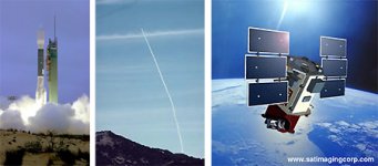
QuickBird at Launch; QuickBird in Orbit
ABOUT THE QUICKBIRD SATELLITE SENSOR
QuickBird is a high resolution satellite owned and operated by DigitalGlobe. Using a state-of-the-art BGIS 2000 sensor (PDF), QuickBird collects image data to 0.61m pixel resolution degree of detail. This satellite is an excellent source of environmental data useful for analyses of changes in land usage, agricultural and forest climates. QuickBird's imaging capabilities can be applied to a host of industries, including Oil and Gas Exploration & Production (E&P), Engineering and Construction and environmental studies
QUICKBIRD SATELLITE SENSOR CHARACTERISTICS
Launch Date October 18, 2001
Launch Vehicle Boeing Delta II
Launch Location Vandenberg Air Force Base, California, USA
Orbit Altitude 450 Km
Orbit Inclination 97.2°, sun-synchronous
Speed 7.1 Km/sec (25,560 Km/hour)
Equator Crossing Time 10:30 AM (descending node)
Orbit Time 93.5 minutes
Revisit Time 1-3.5 days, depending on latitude (30° off-nadir)
Swath Width 16.5 Km x 16.5 Km at nadir
Metric Accuracy 23 meter horizontal (CE90%)
Digitization 11 bits
Resolution
Pan: 61 cm (nadir) to 72 cm (25° off-nadir)
MS: 2.44 m (nadir) to 2.88 m (25° off-nadir)
Image Bands
Pan: 450-900 nm
Blue: 450-520 nm
Green: 520-600 nm
Red: 630-690 nm
Near IR: 760-900 nm
ARCHIVED OR NEW QUICKBIRD IMAGERY FROM THE QUICKBIRD SATELLITE SENSOR
For many image requests, a matching image can already be located in the archives of high-resolution QuickBird imagery from around the world. If no image data is available in the archives, new QuickBird satellite image data can be acquired through a satellite tasking process. For more information and pricing, please visit our Contact Us page.
We care and pride ourselves in maintaining a high standard of customer service by sharing our technical know-how and use our worldwide experiences in remote sensing, geodesy, GIS, GPS surveying and mapping. The Satellite Imaging Corporation (SIC) customer support team and senior staff assure that suitable archived image data is identified and ordered or collected through a new tasking order, to meet the project objectives and specifications by providing the following services:
Negotiations to the attainment of archived or new images with DigitalGlobe
Processing imagery services including orthorectification, color balancing and mosaicing
Advanced Image processing for agriculture, forest, coastal and resource management applications
Extract culture and terrain data in support of GIS and CAD projects
3D Terrain Visualization and modeling for project planning and support
Services to incorporate customer-provided, third party US, and International GIS geospatial data in ESRI's ArcGIS 9.x or other GIS or CAD projects
Consultancy to customers to select band combinations and imaging processing techniques most appropriate to bring out the geographical and manmade features most pertinent to your project. SIC utilizes specialized pansharpening processing techniques to enhance coastal seafloor features and monitor environmental sensitive areas, such as coral zones
Information to customers to assure that correct geodetic and mapping parameters are utilized in support to maintain a "seamless" GIS computer environment for projects involved and to further enhance the spectral analysis for oil and gas, landcover-use classifications, and Environmental Impact Studies (EIS)
New QuickBird satellite image collection at pre-selected time intervals under a subscription tasking program, including attractive pricing discounts, to monitor changes in the environment and progress of construction projects worldwide
For more information and pricing, please visit our Contact Us page.
QUICKBIRD SATELLITE IMAGERY GALLERY
For QuickBird sample images, please visit our QuickBird gallery.
--

