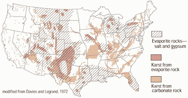
A sinkhole is an alarming yet fascinating feature of mother nature that many do not pay any attention to when considering locations of living. The most damage reported from sinkholes usually occur in the Southeast region of the United States including states such as Texas, Florida, and Alabama. Ranging anywhere from one foot to more than a hundred feet deep, a sinkhole is an area of ground that has no external natural surface drainage. Typically sinkholes go unnoticed while in formation and that is what causes them to be so dangerous. Water beneath the land surface erodes the rock that structures that land eventually leading to a collapse that can be miniscule or devastating and quite expensive to repair. Sinkholes are common where the rock below the land surface is limestone, carbonate rock, salt beds, or rocks that can naturally be dissolved by groundwater circulating through them. Using mapping, geologists have been able to label the locations in which the rock beneath the land surface are most prevalent for erosion. These locations should be considered by those who are looking to settle into houses above these kinds of ground rock. Although the odds are slim of collapsing in a sinkhole, the outcome would be devastating.
I have acted with honesty and integrity in producing this work and am unaware of anyone who has not.
Scott, T. Sinkholes.The USGS Water Science School. p. NA. 2 December 2015.
أكثر...
I have acted with honesty and integrity in producing this work and am unaware of anyone who has not.
Scott, T. Sinkholes.The USGS Water Science School. p. NA. 2 December 2015.
أكثر...